Snow removal · Clarington
Snow removal in Clarington, from the lakeshore to the moraine
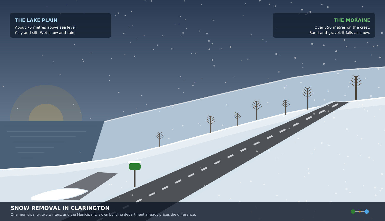
Snow removal in Clarington is really two jobs inside one municipality, because the ground runs from the Lake Ontario shore at Port Darlington up onto the Oak Ridges Moraine, and the Municipality's own building department already stopped pretending otherwise.
Looking for your own corner of it? Courtice and Clarington are covered here.
Green in summer. Clear in winter.
The short answer, before the detail
Clarington starts sanding and salting at anything from a trace up to five centimetres, sends the plows at five centimetres and above, and tells residents that a full plowing operation covering every residential and local road may take up to 24 hours. Nobody at all owes you the ridge the plow leaves across your driveway, and the only Clarington service that touches it is a service for qualifying households whose application window closes on October 31, 2026.
What makes this municipality different from the rest of Durham is the ground. Clarington covers about 614 square kilometres, which is more land than any other municipality in the Region, and it climbs the whole way. A storm that lands as heavy wet snow near the lake is often still falling as snow on the high ground north of Taunton Road an hour later, and the Municipality's own winter storm guidelines are written for all of it at once.
Start with the thing nobody expects: Clarington's building department already settled this
There is a short technical bulletin on the Municipality's website that almost nobody outside the construction trades has read, and it is the single most convincing piece of evidence that Clarington is not one winter. It deals with ground snow load, which is the figure a structural engineer uses to decide how much weight a roof has to carry before it fails.
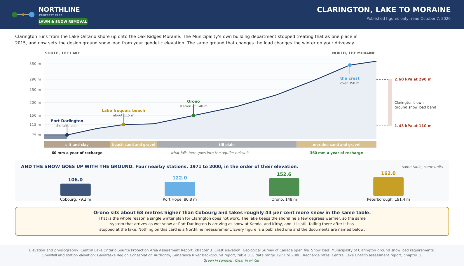
For years one number covered the whole municipality. Then, as the bulletin puts it, the Municipality consulted Environment Canada to review the required ground snow loads for areas other than Newcastle and Bowmanville. The review came back with six different ground snow load zones for the Municipality, set from the geodetic elevation of the property. For ground between 110 metres and 290 metres the published calculation is 1.2 plus the elevation above 75 metres multiplied by 1.4 and divided by 215, giving a result in kilopascals.
Run the ends of that band and the point lands hard. At 110 metres the design load works out at about 1.43 kilopascals. At 290 metres it works out at 2.60. The bulletin separately keeps 1.4 for the Bowmanville area and 1.5 for Newcastle, both of which sit at the bottom of the range. In other words, a roof on the high ground in the north of this municipality has to be designed for close to twice the snow weight of a roof near the lake, and that is not an opinion from a contractor, it is a building requirement published by the Municipality and tied to the Ontario Building Code supplementary standard.
If the Municipality's own building rules change by elevation inside Clarington, a winter plan that does not is simply a worse instrument than the one the building department is already using.
What the ground actually does between the lake and the moraine
Three landforms run east to west across this part of Durham, and Clarington contains all three. The Central Lake Ontario source protection assessment report sets them out in order from the water inland.
The lowest is the Iroquois Plain, the floor of a glacial lake that stood here after the ice left. It runs from Lake Ontario, whose average level the same report puts at 74.75 metres above sea level, up to the old Lake Iroquois beach at roughly 115 metres. That beach is a real ridge of sand and gravel you can still drive over, and it is also named in the Clarington Official Plan as an important landform carrying an east to west corridor of wetland and woodland across the municipality.
Above the beach comes the South Slope, a drumlinized plain of till with thin sand over it. This is most of agricultural Clarington, and the Geological Survey of Canada describes the drumlin field here as erosional forms cut into Newmarket Till, running north northeast to south southwest. Anyone who has driven Concession Road 6 in a crosswind knows those long low hills without needing the word drumlin for them.
Above that is the Oak Ridges Moraine itself. The Survey records Halton Till on the crest in hummocky terrain at elevations over 350 metres, and Parks Canada describes the moraine as standing roughly 100 metres above the land around it. Burketon, Kendal, Kirby and Leskard sit on or against it. Enniskillen, Tyrone and Solina sit on the slope below it. Hampton sits lower again, on a valley floor.
That sequence is why one plan does not fit. A property near the water sits on silt and clay that holds water, drains slowly and freezes into something closer to a skating rink than a snow pack. A property on the moraine sits on sand and gravel that drains almost immediately and takes snow that stays snow. They are different jobs with different failure modes, and the same storm produces both of them on the same morning.
The snowfall numbers, and the honest limits on them
The federal climate service blocked every automated request made to it on October 7, 2026, which is a recurring problem on this site and is reported rather than hidden at the foot of this page. What was available instead is better than nothing and in one respect is better than a single station: the Ganaraska Region Conservation Authority background report publishes a table of local climate stations with their elevations beside their precipitation, drawn from the 1971 to 2000 record.
Read the stations in order of height and the pattern is immediate. Cobourg sits at 79.2 metres and records 106.0 in the snow column. Port Hope at 80.8 metres records 122.0. Orono, inland and up at 148 metres, records 152.6. Peterborough at 191.4 metres records 162.0. Campbellford at 146 metres records 149.3. Orono is the nearest of those to the middle of Clarington and it takes roughly 44 per cent more than Cobourg does, over a rise of about 68 metres and a short run inland.
The temperature column tells the second half. Mean annual temperature falls from 7.3 degrees at Port Hope to 6.8 at Orono to 5.9 at Peterborough, and the coldest month mean falls from minus 5.8 to minus 6.9 to minus 8.9 across the same three. The Conservation Authority states the conclusion itself, writing that on the Oak Ridges Moraine the climate is colder, with harsher winters and later springs than the rest of the drainage area, and that the upland receives greater precipitation, up to 1,000 millimetres, than the shoreline does.
One caution is owed on those figures and it is stated here rather than buried. The column in that table is printed with a millimetre heading, and under the long standing convention for manual stations the same numeral is the snowfall in centimetres, because total precipitation is reported as rainfall in millimetres plus snowfall in centimetres. Rain plus snow sums to the printed total in every row, which is what that convention produces. The ratio between the stations holds whichever way the unit is read, and the ratio is the part this page relies on.
And one modern correction. Environment and Climate Change Canada has retired the fixed centimetre thresholds that used to trigger a snowfall warning and replaced them with impact guides, so alert level now follows expected impact and forecaster confidence rather than a published amount. Any winter article still quoting a numeric warning threshold for southern Ontario is quoting a rule that no longer exists. Clarington falls inside the forecast region Environment Canada calls Pickering, Oshawa and Southern Durham Region, and that region name is the only label the federal forecast puts on this ground.
What Clarington promises, in its own numbers
The Municipality maintains roughly 892 kilometres of road, which it describes as about 1,800 lane kilometres once every lane in both directions is counted, spread across a land area of about 614 square kilometres. For scale, that is more ground than Oshawa, Whitby and Ajax hold between them. Everything below comes from the Municipality's published winter storm guidelines and its winter road maintenance page.
Work is ordered by priority rather than by postcode. Priority 1 is the main arterial roads, and the guidelines name Baseline, Trulls, Nash, Longworth, Holt and the Concession Roads among them. Priority 2 is the secondary collector roads. Priority 3 is residential. If you live on a residential street you are third in that order by design, and no amount of calling moves you up it.
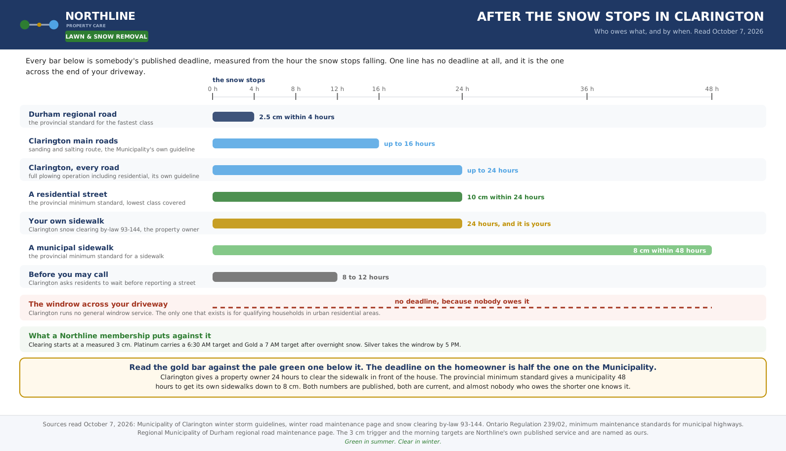
The trigger bands are published and they are worth memorising, because they explain the morning when the road looks untouched and nothing is wrong. From a trace up to five centimetres of accumulation, the operation is sanding and salting rather than plowing. At five centimetres and above, road plowing begins, along with sidewalks and parking lots. A sanding and salting route may take up to 16 hours to complete. A full road plowing operation, including every residential and local road, may take up to 24 hours.
Two more figures round it out. Anti icing liquid goes down as much as three days ahead of a forecast, and pre treatment of the main roads runs up to four hours ahead of a storm, which is why a main road can be wet and black while the snow is still coming down. At the other end, hauling snow away rather than pushing it only begins where accumulated snow passes 60 centimetres at priority locations such as downtown areas and main intersections.
The Municipality also asks residents not to telephone about an unplowed road until at least eight to twelve hours after the storm has ended, and it now runs an online plow tracker that refreshes every five minutes and shows where equipment has been over the previous day. That tracker is free, it answers the question most people are actually asking, and it is a better use of a cold morning than a phone call to anybody, including to me. Durham Region links its own roads the same way, and we keep the municipal instruments gathered on the Durham snow plow tracker page.
One last Clarington rule that catches people out every winter. Parking on the street is already restricted between three and five in the morning and to three hours at any time under by-law 2014-059, and separately you may not park on the street during a snow event at any hour of the day or night. A vehicle left out can be towed, and on a narrow residential street one parked car is usually the reason the plow leaves a wider ridge across four driveways instead of one.
The provincial floor underneath all of it, and the deadline that lands on you
Underneath every municipal guideline sits Ontario Regulation 239/02, the minimum maintenance standards for municipal highways. It does not tell a municipality how to do the work. It describes an outcome, and meeting it gives the municipality a defence under the Municipal Act if somebody sues over the condition of a road.
Roads are sorted into six classes by speed limit and average daily traffic. The regulation does not apply to class 6 at all. For the five it does cover, the snow accumulation table reads: class 1, 2.5 centimetres within 4 hours; class 2, 5 centimetres within 6 hours; class 3, 8 centimetres within 12 hours; class 4, 8 centimetres within 16 hours; class 5, 10 centimetres within 24 hours. The clock starts when the accumulation ends, and the width that has to be produced is the lesser of three metres for each lane or the actual lane width, with a two lane class 4 or class 5 road needing at least five metres in total.
Three things follow from that table and all three matter on a Clarington morning. The first is that a quiet rural concession road and a four lane regional road are not held to anything like the same standard, which is most of the reason one is bare while the other is not. The second is that the standard is a depth, not a finish, so a road can be legally in repair and still be unpleasant to drive. The third is the patrolling table, where a class 1 road is patrolled three times in seven days and a class 5 road once in thirty, which is the real reason a rural problem can sit unnoticed for a week.
Then there is the clause that applies directly to a homeowner and almost nobody knows. The regulation gives a municipality 48 hours after the snow stops to reduce the snow on its own sidewalks to eight centimetres and to leave a metre of clear width. Clarington snow clearing by-law 93-144 gives you 24 hours to clear the sidewalk in front of your own property, across its full width, including the corner links where two sidewalks meet, and expects salt or sand on the ice. If the Municipality has to do it, the invoice is the cost of the work plus a $50 administrative fee.
Twenty four against forty eight. The private citizen carries the tighter deadline, and almost none of the people carrying it have ever been told.
The windrow, and the program that will not reach most of Clarington
The ridge of plowed snow across the foot of a driveway is the part of winter that costs the most effort and belongs to nobody. Clarington states the sequence plainly in its guidelines: driveway windrows are cleared after roadway plowing is complete. What it does not say, because it does not exist, is that a general windrow service is available to residents.
What does exist is the Snow Clearing Program for Seniors and Persons with Disabilities, and the detail of it deserves reading closely rather than skimming, because the eligibility wording is where the municipality stops and a private arrangement starts.
The fee is $107.69 with HST included for the 2026 to 27 winter season. That is the published number and it covers the season rather than a visit.
Applications are open from September 21 to October 31, 2026. There is no language about late entry, and a household that misses it has missed the winter.
Eligibility is 65 or older, or a disability certified by a medical doctor. In either case there must be no able bodied person under 65 living in the home.
The property must be a single family dwelling in an urban residential area fronting a municipal street. This is the clause that decides the shape of the whole thing, and it is dealt with below.
The sidewalk is done within 24 hours of the snow stopping, and only above 7.5 centimetres. Below that depth the service is not initiated at all.
The windrow is done after the roads are finished, and only above 15 centimetres. It is not a response to every storm, it answers a large storm and not a small one.
Clearing stops one metre, or three feet, into the driveway apron. The program opens the mouth of the driveway. It does not clear the driveway.
Businesses, farms, condominiums, vacant properties and vacant land are excluded by name. So is any sand or salt other than what goes down during the clearing itself.
Now the part that matters for this municipality in particular. The program is written for urban residential Clarington, which is Bowmanville, Courtice, Newcastle and Orono. The Official Plan forecasts an urban population of 124,685 against a rural population of 15,655, and the Municipality describes itself as four urban centres and fourteen hamlets. Every one of those hamlets, every farm, and every rural single family home on a concession road is outside the program by its own terms, and so is the longest and most exposed laneway in the Region.
So the fairest summary is this. In urban Clarington there is a cheap public answer for a qualifying household, and nothing a private contractor sells beats it. In rural Clarington there is no public answer at all, which is exactly where the driveways are longest, the wind is worst and the help is furthest away. If your situation is the second one, the long driveway page and the acreage page are the two that actually describe it, and the windrow piece sets out how each Durham municipality answers the same question differently.
Your road may not be Clarington's road, and that changes the morning
Three different authorities clear roads inside this municipality, and which one holds yours decides how early it is touched. It is worth knowing before you decide that somebody is not doing their job.
The Province, through the Ministry of Transportation, holds Highway 401 and Highway 35 and 115. The Region of Durham holds the numbered regional roads. In Clarington those are Bloor Street, Bowmanville Avenue, Boundary Road, Courtice Road, Enfield Road, Ganaraska Road, Liberty Street, Main Street, Manvers Road, Mill Street, Mosport Road, Newtonville Road, Taunton Road and Townline Road. Clarington itself holds everything else, which is most of the network by length and all of the hamlets.
King Street, which is Highway 2, is the exception that catches people. Durham maintains it along its length except for two stretches: between Bowmanville Avenue and Haines Street in Bowmanville, and between Baldwin Street and Arthur Street in Newcastle. In those two sections the Municipality is responsible instead. A driver can cross from one authority to the other twice on a single trip through town without anything on the road saying so.
The Region patrols its roads seven days a week in winter, puts brine down ahead of storms, runs salt through calibrated spinners and operates under a salt management plan. It also runs a depot at Orono that maintains 370 kilometres of road and serves Courtice, Bowmanville, Newcastle, Newtonville, Blackstock and Caesarea, which is the practical reason a regional road through a hamlet is often clear long before the hamlet's own streets are.
The useful version of all that for a homeowner is short. If the big road past the end of your street is clear and your street is not, nothing has gone wrong. Two different bodies with two different standards are working at two different speeds, and the slower one is the one that ends at your driveway.
Salt on the moraine is a different decision, and the reason is the water underneath
This is the part of a Clarington winter that most contractors will never raise with you, and it costs me money to raise it, so take it in that spirit.
The Oak Ridges Moraine is the most significant groundwater recharge area in these watersheds. The Central Lake Ontario assessment report puts recharge on the moraine at roughly 300 millimetres a year, about 40 per cent of the annual precipitation that lands on it, and it breaks that down by what is underfoot. Moraine deposits take about 360 millimetres a year. Glacial lake sand and gravel takes about 240. Newmarket Till takes about 90. The glacial lake silt and clay that most of the Bowmanville and Newcastle lake plain is built on takes about 60.
Six times the infiltration on the high ground, into the same aquifer the high ground drinks from. The source protection area counts 7,964 private wells, and about five per cent of its roughly 320,000 residents are on them rather than on a lake intake. Durham's one groundwater supplied municipal system inside Clarington is at Orono, three wells, two of them 13.7 metres deep and one 12.4, serving roughly 1,793 people. Those are shallow wells by any standard.
A Trent University study of moraine groundwater, working from conservation authority monitoring data, measured average chloride in the Oak Ridges Moraine aquifer at 44.92 milligrams per litre, and concluded that those concentrations likely reflect road salt used at the surface. The same study is careful to say most applied salt leaves in surface runoff rather than infiltrating, which is the honest version and is worth repeating rather than dramatising.
What follows from it on a driveway is practical rather than political. On a moraine or hamlet property with a well, the right sequence is to clear to bare surface first so there is nothing left for salt to melt, to put product down early and thinly rather than heavily and late, and to reach for sand where the problem is traction rather than ice bonding. That is less product sold, and it is the correct answer. On the lake plain, where clay holds water at the surface and refreezes it, the calculation is different and a salting program genuinely earns its place. The piece on driveway salting goes through the temperature at which salt stops working at all, which is the other half of this decision.
And if the driveway is gravel rather than asphalt, which describes a great deal of rural Clarington, the whole order of operations changes again and the gravel driveway piece is the one to read instead.
What Northline puts against all of that, and what it costs
Here is the service, stated plainly so it can be compared with the public standards above rather than admired on its own.
Clearing begins at a measured three centimetres on a residential property, which is lower than the five centimetres at which Clarington sends its plows, because a driveway that is never allowed to build a base is a driveway that does not turn to ice in February. Platinum carries a 6:30 in the morning target after overnight snow and Gold carries a 7 AM target. Silver does not plow the driveway and does not carry a morning target at all: it takes the windrow on a separate daytime pass by 5 PM, and it banks four full clears a season on request. Those are targets rather than promises, and the distinction is kept deliberately.
Membership runs at $129 a month plus HST at the entry tier, $189 in the middle and $279 at the top, taken in twelve equal payments. Only the upper two put a blade on a driveway. If what you want is the driveway open before the car leaves, the $129 tier is the wrong purchase and I would rather say so in October than refund somebody in January. A seasonal snow package, which covers the driveway, the walkway and the salting for the whole winter at the three centimetre trigger, comes to $800 where the property is small, $975 where it is standard and $1,200 where it is large, plus HST in each case. A salt only trip on its own is $25 and a return visit for a windrow is $45.
Clarington is also the municipality where the estate bands come up most often, because the lots are bigger here than anywhere else in the service area. A property between 0.35 and one acre, or any driveway over 100 feet, takes the first estate band: $1,750 for the season, or monthly rates of $229, $349 and $499. A property between one and three acres, or a laneway over 250 feet, takes the second band at $2,600 for the season, with monthly rates of $329, $519 and $739, and any laneway past 400 feet adds a further $200 for each additional 100 feet. Above three acres there is no published price at all, deliberately, because the laneway and the pile placement stop being predictable from acreage and a published number would be one nobody could stand behind. Those properties are settled on a telephone call the same day, from the acreage and the laneway length, without a site visit. The estate page carries the full ladder and the memberships page sets the three monthly tiers side by side.
One honest figure about frequency, because it decides whether any of this is worth buying. Eighteen complete winters of daily records from the nearest long running station give an average of about twelve days a season that pass the three centimetre residential trigger, with a mildest season at four and a worst at twenty four. That is our own reading of that record rather than a published figure, and it is named as ours. It also means the event count is the wrong thing to buy on. What is being bought is a fixed number against a variable sky, and in a municipality measurably snowier at the top than at the bottom, that fixed number is worth more on the moraine than it is down at the water.
If what you want is the arithmetic rather than the geography
This page is about what the ground does. The money question has its own page, built on the same two climate stations plus the lot bands, the municipal windrow sentence and the temperature band where salt and injury both peak. Read what snow removal costs in Bowmanville for the pricing side of the same municipality.
Who should not buy this
Every page selling a winter service should carry this section and almost none of them do.
If you are 65 or older in Bowmanville, Courtice, Newcastle or Orono, or you have a certified disability, with nobody able bodied under 65 at the address, apply to the Municipality instead. One hundred and seven dollars and sixty nine cents covers the season for the sidewalk and the windrow, and nothing I sell competes with that. The only thing I would add is the date: applications close on October 31, 2026, and the program does not clear the driveway itself, so a household with a long driveway may want both.
If you are on the lake plain with a short double driveway, a blower that starts, and nobody who has to be out of the house at a fixed hour, a seasonal package is probably poor value and the arithmetic says so. Buy a winter service for the mornings you cannot miss. Do not buy it for the snow.
If you are on a long rural laneway north of Taunton with a neighbour who already runs a tractor and a blade, that neighbour will almost always beat a priced route on cost, because a route is built around hitting a published morning target across a sequence of properties and that structure is what you are paying for. If the morning target is not worth anything to you, the structure is not either.
And if the only part you cannot manage is the ridge across the end of the driveway, say so and ask for that alone. The windrow return visit exists for exactly that and it is a fraction of a season.
What does not change with any of the above is the calendar. A winter route holds only as many properties as can all be finished by the hour it publishes, which means it reaches capacity, shuts, and stays shut until the following season. The snow season here runs from November 1 to May 1. Most of the searching for this service happens in December and January, which is to say after the point where it could have been arranged without pressure. The booking piece sets out the two dates that actually bind.
Your corner of Clarington
Clarington is too big to describe once. The pages below are written for the ground each one stands on rather than with a place name swapped into the same paragraph.
On the lake plain and in town: snow removal in Bowmanville, which runs down to the exposed water at Port Darlington, snow removal in Courtice on the Iroquois beach ground at the Oshawa boundary, and Newcastle, where the Municipality takes over King Street for a stretch and the lake sits a short walk away.
On the slope and the high ground: Hampton, where two road authorities meet in one village, Tyrone, Solina on roads that belong to Clarington rather than to the Region, and Enniskillen up against the moraine itself. For the year round view of the municipality there is also the Courtice and Clarington page.
What we went looking for and could not find
Everything quoted above was taken from one of the following and nothing else: a municipality, the Region, a conservation authority, a ministry or federal department, a university, or a geological survey. None of it was taken from a rival grounds or snow business, because a price page published by a competitor is an advertising decision and not a measurement. That rule has a cost and this is the bill.
No federal climate normals for any Clarington station. Every automated request to the national climate data service was refused on October 7, 2026, so there is no station snowfall normal for Bowmanville or Orono on this page from the federal source itself. The conservation authority table is used instead, and its record period and its unit question are both stated above rather than smoothed over.
No published elevation for individual Clarington hamlets from a federal gazetteer. The national names and elevation services were unreachable, so this page carries no metre figure for Tyrone, Kendal, Burketon or any other hamlet. The elevations quoted are the ones named in a published report, and the hamlets are described by which landform they stand on instead.
No full list of the six ground snow load zones. The Municipality's bulletin states there are six and gives the calculation for the band between 110 and 290 metres, but the zone map itself is an image and the individual zone values are not in the text.
No Clarington winter control budget line, salt tonnage or current equipment count. The winter pages publish service levels and no money, and the most recent operations report found with cost detail is from 2020. No current season figure is published anywhere reachable.
No numeric winter service level from the Region of Durham. The Region publishes its methods, its patrol frequency and its salt management plan, but no hour or depth target for a regional road, so the provincial minimum standard is used in its place and labelled as the provincial standard rather than as Durham's.
No published count of the Clarington roads in each provincial maintenance class. Without it, nobody outside the Municipality can say how many kilometres sit in the 24 hour class, which is the figure that would actually tell a rural resident what to expect.
No chloride measurement specific to Clarington or to the western side of the moraine. The figure quoted is from the Ganaraska region aquifers to the east, measured by a university rather than by a regulator, and it is the nearest measurement that exists.
No count of private wells in Clarington alone. The 7,964 figure covers the whole Central Lake Ontario source protection area across seven municipalities, and no municipal breakdown is published.
A page that prints only its findings has hidden half the work. Read the list of gaps first, because it is the fairest test of whether anything else here was checked with any care.
Questions people actually ask about snow in Clarington
At what depth does Clarington plow my street?
Clarington publishes two bands in its own winter storm guidelines. From zero to five centimetres of accumulation the work is sanding and salting. At five centimetres and above the plows go out, and sidewalks and parking lots are plowed as well. The Municipality then says a full road plowing operation, including every residential and local road, may take up to 24 hours to complete. Separately, Ontario Regulation 239/02 sets the legal floor, and on the lowest class of road it covers the standard is to get the snow down to 10 cm within 24 hours of the snow ending.
Does Clarington clear the windrow at the end of my driveway?
Not for the general resident, and there is no open program to join. The only windrow service Clarington runs is the Snow Clearing Program for Seniors and Persons with Disabilities. It costs $107.69 with HST included for the 2026 to 27 winter, applications are open from September 21 to October 31, 2026, and it clears the windrow only once accumulation passes 15 centimetres and only after the road plowing is finished. It clears no more than one metre, or three feet, into the driveway apron. It is also limited to a single family dwelling in an urban residential area fronting a municipal street, which means farms, businesses, condominiums and vacant land are excluded by the rules themselves.
How long does a Clarington homeowner have to clear their own sidewalk?
Twenty four hours after the snowfall ends, under Clarington snow clearing by-law 93-144. The duty covers the full width of the sidewalk and the corner links where two sidewalks meet, and the owner is expected to put down safety salt or sand on ice. If the Municipality ends up doing it, the bill is the cost of the work plus a $50 administrative fee. The comparison worth holding on to is that Ontario Regulation 239/02 allows a municipality 48 hours to bring its own sidewalks down to 8 centimetres, so the deadline on the homeowner is half the deadline on the public body.
Why does Bowmanville get less snow than Orono or Kendal?
Elevation, and it is measured rather than folklore. Clarington runs from about 75 metres above sea level at the Lake Ontario shore up onto the Oak Ridges Moraine, where the crest carries ground above 350 metres. In the Ganaraska Region Conservation Authority table of local climate stations for 1971 to 2000, Cobourg at 79.2 metres records 106.0 of snow and Orono at 148 metres records 152.6 in the same column and the same units, which is roughly 44 per cent more. Clarington's own building department reached the same conclusion from the other direction and now sets the design ground snow load from the geodetic elevation of the lot.
Who owns the road I live on in Clarington?
One of three bodies, and it changes what gets cleared first. The Ministry of Transportation holds Highway 401 and Highway 35 and 115. The Region of Durham holds the numbered regional roads, which in Clarington include Liberty Street, Bowmanville Avenue, Taunton Road, Courtice Road, Ganaraska Road, Main Street, Mill Street, Manvers Road, Bloor Street, Boundary Road, Mosport Road, Newtonville Road and Townline Road. Clarington holds everything else, which is the great majority of the network by length. King Street and Highway 2 is the odd one: Durham maintains it except between Bowmanville Avenue and Haines Street in Bowmanville and between Baldwin Street and Arthur Street in Newcastle, where Clarington does.
Does salt work differently on the Oak Ridges Moraine?
The salt behaves the same. What is underneath it does not. The Central Lake Ontario Source Protection Area assessment report puts recharge on moraine deposits at about 360 millimetres a year against about 60 on the lakeshore silt and clay, so water that reaches the ground on the moraine goes down into the aquifer roughly six times as readily as the same water on the lake plain. Rural Clarington draws its drinking water from that ground, and the assessment report counts 7,964 private wells across the source protection area. The practical answer on a moraine property is less salt applied earlier, sand where traction rather than melting is the problem, and clearing to bare surface so there is nothing for the salt to work on.
Who wrote this
Northline Property Care is Andrew's business. It is run out of Oshawa and works east through Courtice, Bowmanville and the rest of Clarington, and west through Whitby, Ajax and Pickering. Six winters of clearing snow in Durham Region sit behind it. That is Andrew's own record rather than a claim about how long the company has traded, because Northline registered in August 2026 and has not yet run a snow season under that name. The person who prices a property is the person who turns up and works on it, and nothing is handed to anybody the customer was not told about.
Clarington deserves a word on why this page exists at all. The largest operator in this market publishes a great many articles and not one of them carries a Durham town name, and their service and city pages stop at the Oshawa line entirely. Bowmanville, Courtice, Clarington and Newcastle appear nowhere in it. That is a routing decision rather than an oversight, and it leaves the municipality with the most ground, the longest driveways and the largest elevation range in Durham with nobody writing about it specifically. Being the one who does is cheaper than outspending anybody.
If a figure above is wrong, 905-244-5779 goes straight to whoever typed it, and that is faster than any correction form.
Read next
Windrow clearing in Durham
How each municipality in the Region answers the same question about the ridge across the driveway, and what each one charges.
Read the windrow piece →When to book snow removal
The two calendar dates that settle a Durham winter, and what happens to a household that reaches one of them late.
Read the booking piece →Snow removal in Bowmanville
The lakeshore end of Clarington, from Port Darlington up through town, and how the service runs there after a storm.
See the Bowmanville page →The work, photographed
Real Northline properties, before and after, every one of them in Oshawa and every one of them this year. Drag the line to compare.
Andrew answers, October 2026
Why is the morning clearing time a target rather than a promise?
Because a promise about the morning is a promise about the weather, and nobody can make one of those honestly. What I can promise is where you sit in the route and the order the route runs in, and both of those are published on this site. In eighteen years of Oshawa data the worst winter had twenty four clearing days and the mildest had four, and a promise written to survive the worst of those is a promise priced for it. A target I actually hit is worth more to you than a promise I have quietly priced the risk of breaking.
One of these goes on each page and it is replaced monthly. If the question you have is not here, ask it: 905-244-5779.
Tell me the road and the acreage and I will tell you the band
Those two answers price a Clarington property more accurately than a photograph does, and on anything over three acres they are the whole quote. If you qualify for the Municipality's program I will say so and point you at the October 31 deadline instead. If you do not, the seasonal number and the monthly number will both be in front of you before November 1, which is when the route closes for the winter.